

Treks In Maharashtra: For individuals who like to experience new things, trekking is a fantastic outdoor activity. Maharashtra is renowned for its plethora of forts, each of which has an intriguing past. You can fulfil your urge for adventure while also learning more about the fort’s construction, history, and present condition by trekking to them. Additionally, these forts typically offer breathtaking bird’s-eye views of the surroundings. So, listed below are some of the top fort treks in Maharashtra.
Treks In Maharashtra
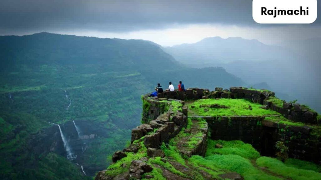
1. Rajmachi
On Rajmachi, there are two fortified peaks: Shrivardhan and Manaranjan. From the base village of Udhevadi, it takes a half-hour to reach the plateau between the two peaks. The historic ruins and advantageous position of Rajmachi Fort make it a popular tourist site. Khandala and Lonavala, two hill towns in Maharashtra, are both 15 kilometres away. There are two strongholds there: Shrivardhan and Manaranjan, and a huge plateau surround them. It is simple to see the Bor Ghat, a crucial commercial route between Mumbai and Pune.
Trek
You have complete control over the hiking route. The Lonavala path is the greatest choice if you have never gone trekking before. It takes a long time to walk from Lonavala. In the base settlement of Rajmachi, the journey starts. You’ll enjoy the hiking path because it is surrounded by woodland and other natural beauty. The final location is reached after a 4 to 5-hour journey. The Kondhane path is the best choice if you’re seeking for an exhilarating journey. Compared to the Lonavala trek path, the Rajmachi trip is a little more difficult. It takes between 2.5 and 3 hours to ascend steeply to the fort.
History of the Fort
The Satavahanas constructed the famous Rajmachi fort complex, which has a rich past. This fort and the adjacent forts were taken from Bijapur’s Adilshahi king by Shivaji Maharaj in 1657. The Marathas were driven out of the fort in 1704 by the Mughal Emperor Aurangzeb. The Marathas seized power again the next year, and Shahu Maharaj subsequently awarded Kanhoji Angre possession of the Rajmachi fort in 1713. The Rajmachi fort and the Maratha territory were taken over by the British when the Marathas were defeated in 1818.
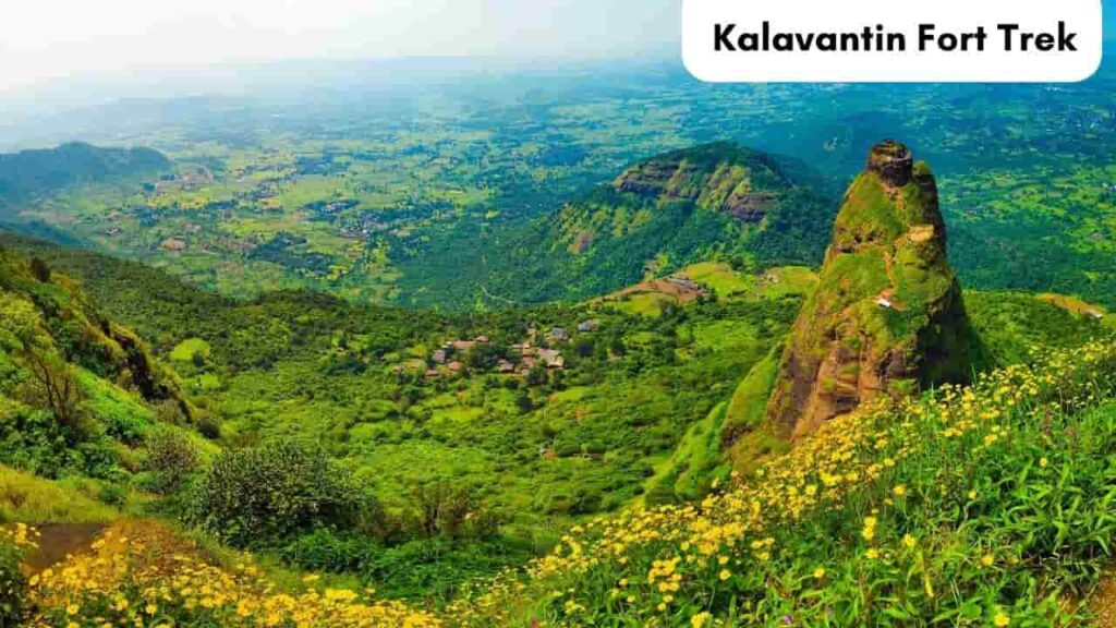
2. Kalavantin Fort Trek
The next fort hike in Maharashtra is the Kalavantin Fort, popularly known as Durg. It is situated along the Old Mumbai-Pune route close to the Prabalgad Fort.
Trek
On this approach, you must climb the rock-cut steps of the mountain that zigzag their way up to the fort. Climbing the steps gives you a broad perspective of the surroundings because they are exposed. Nearly 2,300 feet above sea level, the fort is situated at the mountain’s peak. The fort, which is finally reached, is surrounded by vegetation, making it one of the best fort treks in Maharashtra. It is recommended to avoid making the walk to this fort during the monsoon season.
The hardest part of the Kalavantin Durg walk is the final section, which entails ascending a vertical rock outcrop and navigating a flight of steep stairs in order to reach the pinnacle, which is 685 metres above the ground. The duration of the journey might range from 3 to 5 hours, depending on one’s degree of fitness. The last leg of the journey increases the difficulty of reaching the summit.
History of the Kalavantin Fort
According to mythology, the fort was constructed for a queen by the name of Kalavantin. During the Holi (Shimga) Festival, the Adivasi residents of Prabalmachi village adhere to a custom of dancing atop the Kalavantin fort. It served as a covert hideout for independence warrior Umaji Naik at the beginning of the nineteenth century. The neighbouring Prabalgad Fort, which was constructed circa 530 BC as a 685-meter (2,300-foot) high stone spire during the Bahmani Sultanate, is frequently mistaken with Kalavantin Durg’s history. In the year 1458 AD, the Ahmadnagar Sultanate seized control of the fort. In the centuries that followed, it was subdued by the Mughal Empire and the scene of countless conflicts involving different rulers.
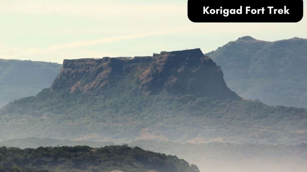
3. Korigad Fort Trek
Hill fort Korigad is in Maharashtra. The fort stands at a height of roughly 2800 feet above the earth in the Pune district. Despite the fact that few of the defences are still surviving, the fort’s entire wall is unbroken. The park has a 2-kilometre-long circumference that can be walked around. There are water cisterns and caves inside the fort.
Trek
One of the simplest fort treks in Maharashtra, the approach to the summit of the Korigad Fort is straightforward and well-marked. Either a temple or a small forest marks the start of the journey to Korigad Fort. The short 45-minute ascent to the pinnacle of Korigad Fort. One of the most well-liked one-day treks in the Mumbai, Thane, and Pune regions is the Korigad Fort Trek. The monsoon season is the ideal time to visit Korigad Fort. The greatest and most suitable hike for newcomers and novices is to Korigad Fort.
History of the Korigad Fort
The Korigad Fort often spelt Koarigad or Koraigad, is situated on the southern outskirts of Lonavala. An estimate of the age of the Korigad fort is 1500 years. The Chatrapati Shivaji Maharaj took the forts of Lohagad, Visapur, Tung, and Tikona by force in 1657. But on March 14, 1818, the British captured this fort from the Marathas. On the southern and eastern flanks of the fort, there is a planned city called Aamby Valley. During the monsoon season, we can witness an incredible sight of water cascading down ancient stairs. The Koraigad Fort is located within the Lonavala Mountain Range. Korigad Fort provides a panoramic view of Tung Fort, Pawna Lake, and Aamby Valley City.
4. Lohagad Iron Fort Trek
The historical Lohagad Fort (Iron Fort) is situated 11 kilometres from Lonavala, 66 kilometres from Pune, and 114 kilometres from Mumbai in the Sahyadri highlands in the Lonavala region of Maharashtra. It is a well-known historical monument in Maharashtra and one of the top fort hikes in the state.

Trek
Driving up to the base village of Lohagadwadi and then walking up the fort’s stone steps is the quickest and simplest method. One more originates in Bhaje, a community located around 5 to 6 kilometres from Malayali. From the settlement of Bhaje, one can walk to Gaumukh Khand. Here is where one could get confused. A left turn would take us to the Visapur fort, so we must make a right. After turning left, we must travel till we see the stairs of the fort.
History of the Lohagad Iron Fort
The Lohagarh Fort is a unique historical location. Lohagad, which translates to “fort of iron,” is a fort that is essentially impenetrable. Because of the fort’s extensive moats on all sides, it was previously generally thought that it could only be destroyed “if a crocodile swallowed up all the water in the moat.” The 1730s-era fort today primarily houses a museum and the government’s offices.
5. Ratangad Fort Trek
In the Ahmednagar district of Maharashtra, 6 km from Ratanwadi, 23 km from Bhandardara, 183 km from Pune, and 197 km from Mumbai, is the historic hill fort of Ratangad. It is a fantastic destination close to Mumbai and Pune and one of Maharashtra’s top fort hikes.

Trek
Your stamina will be put to the test when you start out on the trek route because of the terrain’s somewhat hard uphill climb. It’s advised that you hire a guide for a safe and swift climb to the fort because the path is somewhat ragged and it’s easy to miss your route if you travel during a fog season. The ascent through the jungle is challenging, but two plateaus that appear in the middle of the ascent provide some reprieve. You may reach the Tryambak darwaja, the fort’s main entrance, by climbing the ladders you’ll find in the final section of the journey, which will be a breeze.
History of the Ratangad Fort
During his rule, Chatrapati Shivaji Maharaj overcame the 400-year-old fort of Ratangad. Its base village, Ratanwadi, is where is situated, and it overlooks the Bhandardara.
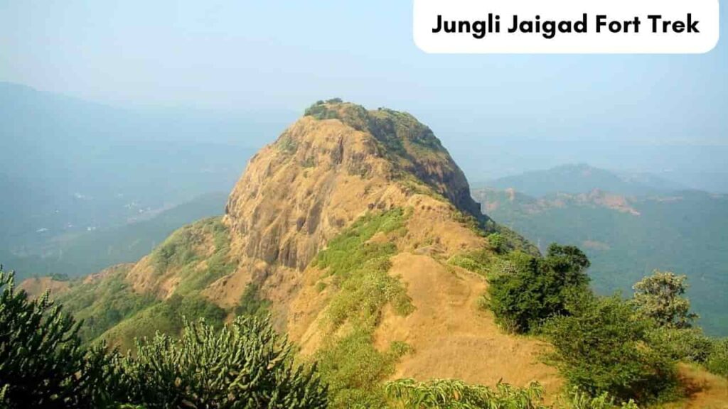
6. Jungli Jaigad Fort Trek
The fort is close to Koyna Lake in Satara. Winter, when the weather is moderate and there is no possibility of rain, is the ideal season to visit the fort. Given that the fort is 2957 feet above sea level, you can picture what the view would be like from the top. You’ll probably witness a variety of animals and birds since you’ll be surrounded by woodland.
Trek
One of the most fascinating treks through a thorny forest that offers thrill-seekers an exhilarating experience is the Jungli Jaigad fort hike. It is also recognised as one of the top treks in Maharashtra. It takes 3–4 hours to hike from the base village of Navja, which is close to Koyna Nagar. When you get to the top, you’ll be rewarded with beautiful views of the Kumbharli Ghat and the Koyna dam backwaters. The greatest season for a hike to Jungli Jaigad Fort is winter. Camping at the fort is not advised because of the fauna there.
History of the Jungli Jaigad Fort
In the sixteenth century, the Jaigad fort is credited to the Bijapur Kings. Later, it ended up in the possession of Sangameshwar’s Naiks. He was in charge of 600 soldiers and 7-8 villages. He defeated the united troops of Bijapur and the Portuguese in 1583 and 1585, respectively. One of the 10 forts that Balaji Vishwanath Peshwa gave to Kanhoji Angre in 1713 was Jaigad. In June 1818, the British took control of this fort without a struggle.
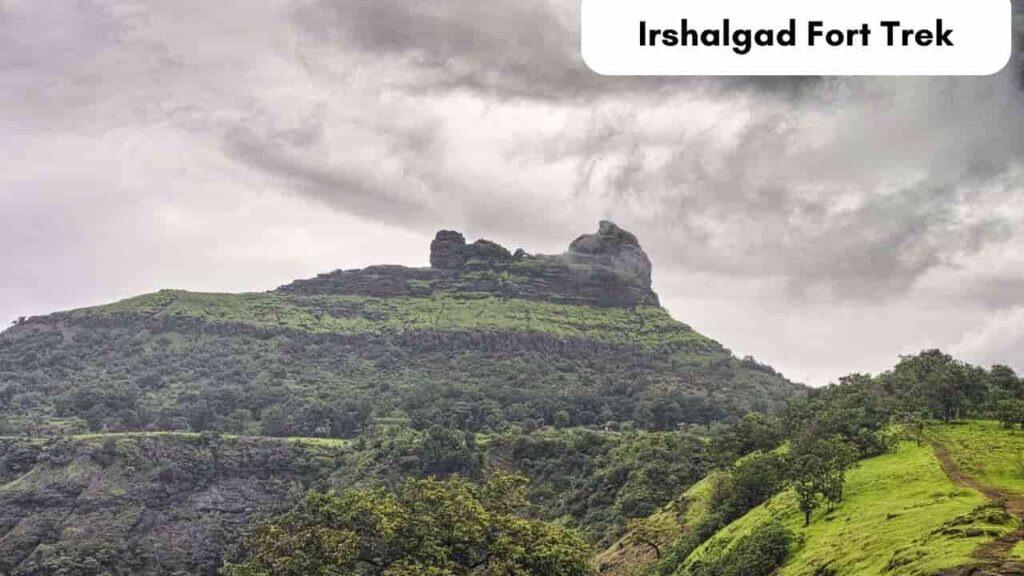
7. Irshalgad Fort Trek
Prabalgad Fort’s companion fort, Irshalgad Fort, is 3700 feet above sea level. It was constructed under the Bahmani Sultanate. The site has several thrilling hiking trails and is surrounded by a thick forest. Mountaineering is also a great activity at Irshalgad peak. It is worth the journey to see the expansive vista of the Western Ghats from the vantage point at the top of the attraction.
Trek
To get to Irshalwadi village, you must take a taxi from the closest train station, Karjat. If travelling by road, one can take a private vehicle up to Chowk/Chauk village. The journey to the fort then takes around an hour. Both the ascent and the descent last roughly two hours each. Avoiding the busiest summer and monsoon seasons, the best months to embark on the journey are from August to March.
History of the Irshalgad Fort
Irshalgad isn’t a fort; it’s a pinnacle, which makes the name deceptive. It hasn’t happened very often in history. Maybe it was a watchtower for the region between Manikgad and Prabalgad. In May 1666, Shivaji Maharaj seized control of the territory between Kalyan and Bhiwandi and Rairi. Irshalgad was possibly governed by the Maratha during the time. Its border with Prabalgad is shared. Kumar Prakash Durve perished on January 23, 1972, after falling from this vantage point. All hikers from the Mumbai-Thane region congregate here on January 26 each year to remember this day.
8. Raigad Fort Trek
At an elevation of roughly 820 metres, the picturesque Raigad Fort is positioned atop the Sahyadri mountain range near Mahad, Maharashtra. The magnificent fort can only be accessed from one side due to the other three sides being enclosed by deep valleys, which require 1737 steps. The fort serves as a reminder of the Marathas’ bravery and audacity and is a source of tremendous pride for them. The Raigad fort is a significant pilgrimage place that embodies Chhatrapati Shivaji’s lofty idea of Hindavi Swarajya and is more than just a tourist destination. Even though it is now mostly in ruins, the fort nevertheless extols the heroic past of the Marathas.

Trek
You can either take the bus or the steps to go to Pachad if you like to hike. You will need to ascend 1737 steps in order to reach the fort. To get to the fort, however, there is also the Raigad Ropeway, an aerial tramway, which takes 4 minutes. For those who don’t like trekking, there is a ropeway that takes you to the Raigad Fort. It is only 4 minutes long, 760 metres long diagonally, and features a 420-metre ascent. Whistling winds and stunningly lush foliage are encountered as the ropeway ascends to the summit of this magnificent fort. In addition to the ropeway, the purchase includes admission to the museum and a movie.
History of the Raigad Fort
This superb fort was built in 1030 by Chandrarao Mores. In 1656, Chhatrapati Shivaji Maharaj conquered the Chandrarao Mores royal family, a Cadet dynasty descended from the historic Maurya Dynasty. Shivaji extended and repaired the Rairi fort, renaming it Raigad, which means “King’s Fort.” It was also regarded as the seat of the Maratha monarchy. Shivaji Maharaj constructed Fort Lingana close to the Raigad Fort after taking it. In 1765, a British East India Company armed expedition had the fort as its objective. On May 9, 1818, it, at last, became a British colony.
9. Kavlya Fort Trek
The Kavlya fort climb is one of Maharashtra’s least popular fort treks despite being situated near the well-known tourist area of Varandha Ghat. Raigad in the Konkan and Pune in the Ghats are connected by the Varandha Ghat, a significant road. To keep an eye on this passage, the Kavlya fort was constructed.

Trek
The Kavlya fort climb is one of the least frequented forts in Pune, Maharashtra, even though it is situated in the well-known tourist area of Varandha Ghat. Raigad in the Konkan and Pune in the Ghats are connected by the Varandha Ghat, a significant road. To keep an eye on this passage, the Kavlya fort was constructed.
The Fort’s history
The history of the Kavlya fort is not well known. It was built to safeguard and protect Varandha Ghat. Because traders travelled the Varandha Ghat pass frequently, the British government built a paved road there in 1857. There were two distinct parts of the fort.
10. Sondai Fort Trek
Another popular fort hike in Maharashtra during the monsoon season is the Sondai Fort Trek. The area is covered in beautiful vegetation. The Sondai walk will be tranquil and calm because it is still a new experience. It is close to Karjat and provides a stunning view of the Matheran range and Morbe dam. While hiking to the fort, you can pause at the Sondewadi settlement for a cup of tea. Along the way, you’ll see water-filled cisterns and an idol of Sondai Devi at the summit.
Couldn’t find an image in the public domain
Trek
It takes roughly an hour to finish the moderately challenging Sondai fort trek. The trail gets a little trickier during the monsoon because the rock steps get slippery. There are two ways to get to the fort. The one from Wavarle has a more challenging approach because it travels through a heavily forested area, making the one from Sondewadi preferable.
The Fort’s history
To serve as a lookout and monitor the surrounding area, the Sondai Fort was constructed. The mountain gets its name from a temple honouring the Goddess of Sondai that stands atop it. The tree above the temple serves as its wall because it lacks a solid framework.
11. Rajgad Fort Trek
One of Maharashtra’s most stunning fort hikes is the Rajgad Trek. As its name suggests, it is the king of forts. Due to its fascinating architecture and long history, the fort stands out among other forts in the western ghats. It is 4,514 feet high and situated close to Pune. The hill Murumb Devacha Dongar, with a diameter of almost 40 kilometres, is where this fort was built. The huge size of the fort made it challenging to lay siege to it, giving the Marathas time to plan their attack.

Trek
On this thrilling hike from Pune to the ruins of the Ancient Fort and the Padmavati shrine, travel back in time. The Gunjavane Village near Pune is the starting point of the moderately challenging Rajgad Trek, which concludes at the Rajgad Fort.
The Fort’s history
It honours Chhatrapati Shivaji, a well-known Indian emperor, and serves as a reminder of the Maratha army’s successes and fights. When it was first constructed, the fort was called Murumbdev and was ruled by the Maratha kings. Only after Chhatrapati Shivaji moved his capital to Rajgad was this fort restored and given a new name.
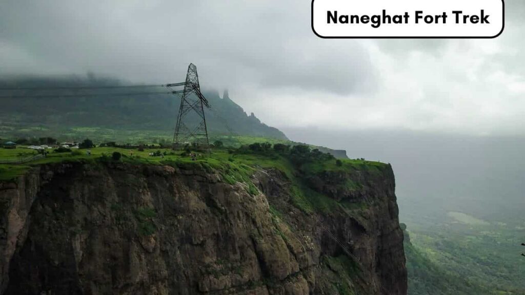
12. Naneghat Fort Trek
Thirty kilometres from Malshej Ghat is Naneghat, a mountain pass in Maharashtra, India’s Western Ghats. On the Kalyan-Ahmednagar Highway, it is one of the most picturesque trekking locations in Maharashtra and is close to the village of Vaishakhare. For those looking for adventure, it’s also one of the must-do fort treks in Maharashtra.
Trek
Starting from the Ahmednagar-Kalyan road, Vaishakhare serves as the starting village for treks to the Naneghat. From the bottom to the top, the hiking track is 4.5 kilometres long, and it takes around 2.5 hours to finish one side. Even novice hikers are able to accomplish the reasonably easy Naneghat trip. The entire length of the path is made up of a variety of geographical terrains.
The terrace offers amazing views of Jivdhan Fort and Bhairavnath Temple and is great to explore. There are several places to stop and rest where one may simply take in the panoramic splendour of the surroundings. In addition to hiking, there is a motorable road that extends from the Ghatghar region all the way to the top to get to Naneghat.
The Fort’s history
At an elevation of 2,600 feet, Naneghat—also known as Nanaghat or Nana Ghat—was a stop on an old trade route during the rule of the Satavahana (about 200 BCE–190 CE). It connected the Deccan high plateau with the Konkan coast villages via Junnar. The terms nane, which means “coin,” and ghat, which means “pass,” are combined to form the name Nane Ghat. Tolls from traders passing through the hills were collected using this passage as a tollbooth. One of the most popular Malshej Ghat tourist destinations is it.
13. Harishchandragad Trek
In the Maharashtra district of Ahmednagar, 8 kilometres from Khireshwar, 15 kilometres from Malshej Ghat, 50 kilometres from Bhandardara, 166 kilometres from Pune, and 218 kilometres from Mumbai, is the mediaeval hill fort of Harishchandragad. As part of Malshej Ghat tours, it is one of the most well-liked fort hikes in Maharashtra and one of the state’s most popular historical monuments.

Trek
The fort, which stands 1,424 metres above sea level, once had a significant impact on the protection and management of the neighbourhood. The fort, one of Malshej Ghat’s most visited tourist destinations, was constructed in the sixth century under the rule of the Kalchuri dynasty. The citadel was built during this time, and many caves were probably hollowed out around the 11th century AD.
The sage Changdev meditated here in the fourteenth century. After the Marathas overthrew the Mughals in 1747 AD, the fort eventually came under the authority of the Mughals. Here, human artefacts from the Microlithic era have been found. Various Puranas, such as the Matsya Purana, Agni Purana, and Skanda Purana, mention Harishchandragad’s fort.
The Fort’s history
There are three well-liked trekking paths to the fort: through the villages of Paachnai, Nalichi Vaat, and Khireshwar.
Trekking takes two to two and a half hours one way along a straight path from Khireshwar village to Tolar Khind. Malshej Ghat Bus Stop, which is close to Khubi Phata Village, is around 7 kilometres from Khireshwar Village. From Junnar Darwaza, which is close to the base settlement, one may see the caverns. This route takes you straight to Tolar Khind. There is a 100-foot rock area with iron fences for trekkers’ safety after Tolar Khind. After passing through a rock formation, a straight path with little hills and streams in between leads to the Harishchandreshwar Temple.
Paachnai village, 48 kilometres from Bhandardara, is another way to get to Harischandragad. From Paachnai, one needs to hike 5 kilometres to Harishchandragad. The forest’s natural splendour can be seen from the easy and lovely trekking path. It takes roughly three hours to ascend Harischandragad to the peak. Along the journey, there are many rocky outcroppings and challenging climbs.
The third route is intended exclusively for hikers and starts at Belpada hamlet and goes to Sadhleghat. Sadhleghat is on the exceedingly challenging route that leads from here. This area requires climbing a straight rock section with handholds. From here, the trail continues to be rocky and upward. Belpada village is 19 kilometres away from the fort, and it takes 9 hours to go there (on the way). It is legal to camp at the summit.
14. Tikona Fort Trek
In Maharashtra’s Maval district of Lonavala, Tikona Fort, also known as Triangle Fort, is a significant hill fort that is situated 22 kilometres from Tung Fort and 21 kilometres from Lohagad Fort. It is situated 53 kilometres from Pune and 135 kilometres from Mumbai. The fort is a well-liked day-trip location between Pune and Mumbai and one of the top fort hikes in Maharashtra. At 3633 feet above sea level, Tikona Fort, also called Vitandgad Fort, is located.
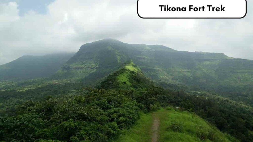
Trek
The Tikona Fort trip is most accessible from the settlement of Tikona Peth. There is a motorable road that connects the settlement of Tikona Peth with the fort’s base, which is 2 kilometres away. The moderately challenging trek from the fort’s base takes one to one and a half hours. On the approach to the summit, there is a cave and then a statue of Lord Hanuman. There is a path next to the cave that leads to the bastion’s entrance. To reach the summit of the fort from here, one must ascend around 100 steep stairs. The steps are divided into two parts. Support for climbing is provided by a fixed rope with bolts.
The Fort’s history
This magnificent Fort, unlike the many other forts in the state, is devoid of historical details. The fort was taken over by the Nizam Shahi dynasty in 1585 AD and incorporated into the Nizam dominion. Tikona, together with the forts of Karnala, Lohagad, Mahuli, Songad, Tala, and Visapur, were all taken by Shivaji Maharaj in 1657 AD, giving him authority over the whole Konkan, which had been Nizam territory. The Tikona fort was ceded to the Mughals in accordance with the Treaty of Purandar, which was signed on June 12, 1665, although it was afterwards retaken by Shivaji Maharaj in 1670 AD.
15. Harihar Fort Trek

The Upper Vaitarana range, near Trimbak in Maharashtra’s Nashik district, contains the small hill fort known as Harihar Fort or Harihargad, which is 22 kilometres from Trimbakeshwar and 45 kilometres from Nashik. One of the most well-liked monsoon fort hikes in Maharashtra is the fort, also known as Harshgad or Harishgad.
Harihargad, which is only reachable from one side through a 200-foot-high rock-cut staircase, is situated on a triangle rock with all three sides vertical at an elevation of 1120 metres (3676 ft). The most remarkable part of this walk is the 80-degree rock-cut steps that must be climbed to enter the fort. Despite being a vertical ladder, the steps have grooves for a secure grip as you climb. There are 117 steps in all. The experience of ascending and descending through this stretch is exhilarating.
.jpg)
After ascending this first flight of stairs, you will arrive at the Darwaja, which is the fort’s entryway. The next section of the path is quite small and requires tremendous caution to travel. There are 100 steep stairs to walk up to the fort’s peak. The fort has a higher level in the middle of a tapering plateau. There is a modest temple to Lord Hanuman and Lord Shiva on the plateau. There is a tiny pond with drinkable water in front of the shrine. There is a little palace with just two rooms inside the fort. Five cisterns line one side of the palace, one of which holds drinkable water.
The Harihar Fort trek begins in Nirgudpada, which is 22 kilometres from Trimbakeshwar. Visitors must hike 4 kilometres from the base settlement to the Harihar Fort. It takes around two hours to make the moderate ascent to the fort’s summit.
The Fort’s history
The Harish Fort was one of the forts that belonged to the Ahmadnagar Sultans. In the year 1818 AD, Captain Briggs visited there. In 1636 CE, Shahaji handed the Mughals several forts, including Harishgad, Trimbakgad, Tringalwadi, and others. Harishgad was one of the 17 strongholds that the British captured during the fall of Trimbak in 1818 CE.